St. George Golf Elevation and Distance: Course Altitudes Around Southern Utah, Big Drops and How They Change Your Clubs
St. George, Utah golf elevation explained: every course altitude from Mesquite to The Ledges, the biggest tee-to-green drops, and how they change your clubs.
Open the 3D map of every course →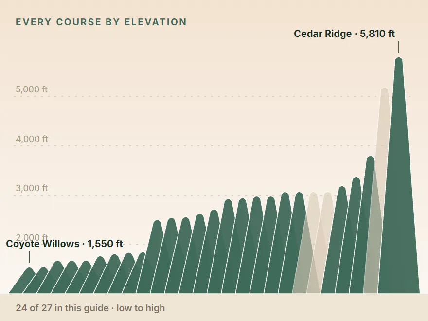
St. George, Utah golf courses sit between about 2,512 and 3,810 feet above sea level, from the valley courses in town up to The Ledges above Snow Canyon, with the Hurricane courses near the top of that range. The Mesquite, Nevada courses down I-15 are lower, at roughly 1,550 to 1,860 feet. At the higher end the ball flies a bit farther, but the bigger effect on your distances is the elevation change inside each hole, where some tee shots drop more than 100 feet to the green.
Think of St. George golf elevation and distance in three layers: the altitude of the course, the rise or fall of each hole, and the total climb over a round. Each one matters for a different reason, and the map of Southern Utah golf makes the pattern easy to see.
Layer 1: St. George golf elevation, course by course
These are course elevations from our research records (The Ledges figure is at the clubhouse), with the metric figure from the map data.
| Course | Elevation | Town |
|---|---|---|
| The Ledges | 3,810 ft (1,160 m) | St. George |
| Copper Rock | 3,384 ft (1,031 m) | Hurricane |
| Sky Mountain | 3,197 ft (973 m) | Hurricane |
| Sand Hollow Championship | 3,079 ft (940 m) | Hurricane |
| Coral Canyon | 3,077 ft (931 m) | Washington |
| Dixie Red Hills | 2,988 ft (907 m) | St. George |
| Black Desert | 2,987 ft (911 m) | Ivins |
| Entrada at Snow Canyon | 2,953 ft (899 m) | St. George |
| Green Spring | 2,936 ft (892 m) | Washington |
| Sunbrook | 2,724 ft (830 m) | St. George |
| St. George Golf Club | 2,637 ft (804 m) | St. George |
| Southgate | 2,569 ft (782 m) | St. George |
| Bloomington Country Club (private) | 2,555 ft (776 m) | St. George |
| SunRiver | 2,512 ft (763 m) | St. George |
| Conestoga | 1,860 ft (567 m) | Mesquite |
| Wolf Creek | 1,850 ft (564 m) | Mesquite |
| Beaver Dam Lodge | 1,820 ft (556 m) | Beaver Dam, AZ |
| Falcon Ridge | 1,780 ft (541 m) | Mesquite |
| Oasis Palmer and Canyons | 1,690 ft (514 m) | Mesquite |
| Palms | 1,690 ft (515 m) | Littlefield, AZ |
| CasaBlanca | 1,560 ft (477 m) | Mesquite |
| Coyote Willows | 1,550 ft (471 m) | Mesquite |
What the altitude does to your distances
The Ledges is the highest course in the area, and our research notes it plays slightly cooler with the ball flying a bit farther. That's the honest size of the effect inside St. George: the whole Utah-side spread is about 1,300 feet, from SunRiver to The Ledges, so you won't hit a club less everywhere you go.
The bigger altitude jump is between St. George and Mesquite. The Ledges sits about 2,250 feet above CasaBlanca, and even SunRiver, the lowest Utah course, is about 650 feet above Wolf Creek. If you play a high course one day and Mesquite the next, expect the ball to fly a little shorter down in Mesquite and give it a few holes to recalibrate.
We don't quote a carry-distance percentage for any of these courses, because no course or source in our files publishes one. Trust what you see on your first few shots.
Where the high and low courses sit around St. George, Utah
Elevation follows geography here. Sort the courses by area and a clear pattern shows up: the west side and the east side are higher, the valley courses in town are lower, and everything across the Nevada line drops away.
| Area | Courses | Elevation range | From downtown St. George |
|---|---|---|---|
| West side, Snow Canyon and Ivins | The Ledges, Entrada, Black Desert, Sunbrook | 2,724–3,810 ft | 12–15 min |
| Central St. George and Bloomington | Dixie Red Hills, St. George Golf Club, Southgate, Bloomington, SunRiver | 2,512–2,988 ft | 7–14 min |
| Washington | Green Spring, Coral Canyon | 2,936–3,077 ft | 12–17 min |
| Hurricane | Sand Hollow, Sky Mountain, Copper Rock | 3,079–3,384 ft | 28–36 min |
| Beaver Dam and Littlefield, AZ | Beaver Dam Lodge, Palms | 1,690–1,820 ft | 39–57 min |
| Mesquite, NV | Conestoga, Wolf Creek, Falcon Ridge, Oasis, CasaBlanca, Coyote Willows | 1,550–1,860 ft | 50–56 min |
| Cedar City (off the main map) | Cedar Ridge | ~5,810 ft | ~58 min |
Drive times are free-flow routing estimates from downtown St. George.
The west side. The Ledges sits on the cliffs above Snow Canyon State Park, which is why it tops the list; our Ledges guide covers it in detail. Entrada and Black Desert in Ivins sit a little under 3,000 feet. Our Ivins and Snow Canyon golf guide groups the west-side courses.
The east side. The three Hurricane courses are the next highest group, all above 3,000 feet, with Copper Rock at about 3,384. Coral Canyon in Washington is almost exactly level with Sand Hollow. See Hurricane, Utah golf and Washington, Utah golf.
Down I-15. Mesquite and the Arizona courses near it sit roughly 650 to 2,250 feet below the Utah courses. Mesquite is also about 7°F warmer than St. George in January. Our Mesquite day trip from St. George covers the drive.
Up I-15. For a real altitude change, look north. Cedar Ridge in Cedar City sits at about 5,810 feet, about an hour from St. George, and its record notes the ball carries noticeably farther there than in St. George. It's also much cooler in summer, when St. George highs reach about 102°F in July. Thunderbird at Mount Carmel Junction, east of Zion, sits at about 5,200 feet. See Cedar City and Southern Utah golf.
Layer 2: the drop or climb on each hole
When golfers ask about St. George golf elevation and distance, they usually mean the town altitude, but this is the layer that changes club choice. Our map measures each tee and green against USGS terrain data, and the difference (how far the green sits above or below the tee) is shown for every hole in the course panel. Here are the biggest ones.
| Course | Hole | Par / yards | Tee to green |
|---|---|---|---|
| Falcon Ridge | 12 | Par 5, 505 | 167 ft down |
| Wolf Creek | 17 | Par 5, 562 | 152 ft down |
| Oasis Palmer | 8 | Par 5, 521 | 150 ft down |
| Oasis Palmer | 5 | Par 5, 535 | 138 ft down |
| Falcon Ridge | 6 | Par 4, 392 | 125 ft down |
| Conestoga | 2 | Par 3, 187 | 108 ft down |
| Palms | 15 | Par 5, 543 | 102 ft down |
| Green Spring | 18 | Par 5, 490 | 101 ft down |
| Falcon Ridge | 9 | Par 4, 325 | 96 ft up |
| Conestoga | 5 | Par 3, 202 | 95 ft down |
| Coral Canyon | 14 | Par 4, 382 | 92 ft down |
| Southgate | 18 | Par 5, 515 | 90 ft down |
| Copper Rock | 13 | Par 4, 477 | 81 ft down |
| Sunbrook (one of its 27) | 6 | Par 4, 447 | 79 ft down |
Yardages here are measured along the mapped centre line, close to the middle tees, so they can differ from the scorecard.
Where the drop actually happens
A tee-to-green number is a net figure. A hole can fall 100 feet off the tee and climb part of the way back to the green, and the net hides that. A drop beside the hole doesn't show up at all. Two examples from the course records:
- Coral Canyon #1: the drive drops about 100 feet from a tee high above the course, then the approach plays uphill. Net tee to green: 35 feet down.
- Sand Hollow #12: this par 4 runs along the gorge with a drop of about 100 feet down the left side, yet its green sits 53 feet above the tee in our data. The cliff is beside you, not under the ball.
So on the big holes, think about each shot separately. The tee shot on Coral Canyon's first plays downhill and the approach plays uphill, while Sand Hollow's 12th climbs as you play it.
Par 3s are where it bites
On a par 3 the whole elevation change is in one swing. A few to plan for:
- Conestoga #2 and #5, 108 and 95 feet down.
- Falcon Ridge #14, a 184-yard par 3 described as severely downhill from the Silver tees (67 feet down in our data).
- Copper Rock #17, 136 yards and 44 feet down from the highest point on the course.
- Sand Hollow #15, about 230 yards from the low back tee over a ravine to a cliff-edge green.
A downhill par 3 asks for less club than the yardage says, and an uphill one asks for more. How much depends on the drop, the wind and your ball flight, which is why a rangefinder that shows slope earns its keep here. Reviewers say Conestoga's carts have no GPS, so bring a rangefinder or the course app there.
Layer 3: the total climb over a round
Add up every hole's rise and fall and you get a sense of how hilly a course plays. These totals count tee-to-green changes only, not the drive or walk between a green and the next tee.
| Course | Total up | Total down | Feel |
|---|---|---|---|
| SunRiver | 26 ft | 60 ft | Flat valley course |
| St. George Golf Club | 42 ft | 104 ft | Nearly flat |
| CasaBlanca | 90 ft | 82 ft | Flat river bottom |
| Sky Mountain | 139 ft | 193 ft | Mesa top, open to wind |
| Sand Hollow Championship | 158 ft | 158 ft | Rolling, back nine on the rim |
| Copper Rock | 160 ft | 200 ft | Flat front, hilly back |
| Coral Canyon | 208 ft | 307 ft | Canyon drops and climbs |
| Green Spring | 246 ft | 339 ft | Canyon holes |
| Sunbrook (27 holes) | 251 ft | 432 ft | Elevation and lava |
| Falcon Ridge | 343 ft | 582 ft | Plateau tees |
| Oasis Palmer | 311 ft | 630 ft | Canyon target golf |
| Wolf Creek | 211 ft | 631 ft | Ridge-top tees |
Notice that the Mesquite canyon courses go down far more than they come up between tee and green. The climbing happens between holes, usually in a cart, as you ride back up to the next elevated tee. At Wolf Creek, the terrain makes it cart-only in practice. If you prefer to walk, our walking golf in St. George guide uses these numbers to pick the flattest courses.
The Hurricane courses are a useful middle ground. They sit high, but the totals are modest; at Sky Mountain the challenge is wind on an exposed mesa rather than hills, and at Copper Rock nearly all the movement is on the back nine.
How to use St. George golf elevation and distance on your trip
- Don't overthink town altitude. Within St. George, the change between courses is small. Hit a few balls on the range and play.
- Plan for the big holes. Before the round, check the course panel on the map for any hole with a drop or climb over about 50 feet, and decide how you'll club it.
- Watch the Mesquite switch. Courses there are lower and warmer. Mesquite is about 7°F warmer than St. George in January.
- Pick tees with the elevation in mind. Elevated tees, big drops and forced carries are part of what makes Copper Rock, Coral Canyon and Wolf Creek play hard from the back. Our hardest golf courses in St. George list ranks them.
The Ledges course guide and Copper Rock course guide show the per-hole numbers for the two highest courses. For how temperature and wind change month to month, read St. George golf weather by month, and for the trade-offs of crossing the state line, St. George vs Mesquite golf.
Plan it on the map
Every course on the 3D map of St. George golf shows its elevation, and each hole shows its tee-to-green rise or fall. Open the courses on your list, find the holes with the biggest numbers, and you'll know where to take an extra look at the yardage before you get there.
Courses in this guide
Questions golfers ask
What is the elevation of golf courses in St. George, Utah?
The St. George area courses sit between about 2,512 feet (SunRiver) and 3,810 feet (The Ledges) at the clubhouse. The Mesquite, Nevada courses are lower, from about 1,550 feet (Coyote Willows) to 1,860 feet (Conestoga).
Does the golf ball go farther in St. George, Utah?
A little, at the higher courses. The Ledges, the highest course in the area at about 3,810 feet, is noted as slightly cooler with the ball flying a bit farther. The difference between St. George courses is modest; the tee-to-green elevation changes on individual holes affect club choice far more.
Which St. George golf course has the most elevation change?
On the Utah side, Green Spring has the largest single tee-to-green drop in our map data (101 feet on its 18th), and Coral Canyon's 14th drops 92 feet. In Mesquite, Falcon Ridge's 12th drops 167 feet and Wolf Creek's 17th 152 feet.
Is Mesquite, Nevada lower than St. George, Utah for golf?
Yes. The Mesquite courses sit roughly 1,550 to 1,860 feet up, while St. George area courses run about 2,512 to 3,810 feet. The gap between The Ledges and CasaBlanca is about 2,250 feet, and Mesquite is about 7F warmer than St. George in January.
Which golf courses near St. George are at the highest elevation?
The Ledges on the west side, at about 3,810 feet above Snow Canyon State Park, then the three Hurricane courses: Copper Rock (about 3,384 ft), Sky Mountain (3,197 ft) and Sand Hollow (3,079 ft). Off our main map, Cedar Ridge in Cedar City sits at about 5,810 feet.
How should I adjust clubs for elevation in St. George?
Treat the big downhill and uphill holes as the main adjustment rather than the town's altitude. Use a rangefinder or GPS that shows the slope, watch where the ball lands on the first few drop shots, and adjust from there. We don't quote a fixed percentage because none is published for these courses.
Keep reading
 CoursesEvery Golf Course in St. George, Utah and Around It: Where It Is, Who Can Play, What It CostsEvery St. George, Utah golf course plus Mesquite: town, access, par, drive time from downtown and green fees seen October 2026, sorted by side of town.10 min read
 PlanningSt. George Tee Times: How Far Ahead Each Course Lets You Book (and When to Set Your Alarm)St. George, Utah tee times: booking windows for every course, from 14 days at the city courses to 180 at Sand Hollow, plus Mesquite and cancellation rules.9 min read
 PlanningHow to Plan a St. George, Utah Golf Trip, Step by StepPlan a St. George, Utah golf trip in six steps: when to go, Las Vegas vs St. George flights, where to stay, which courses to mix, and when tee times open.9 min read